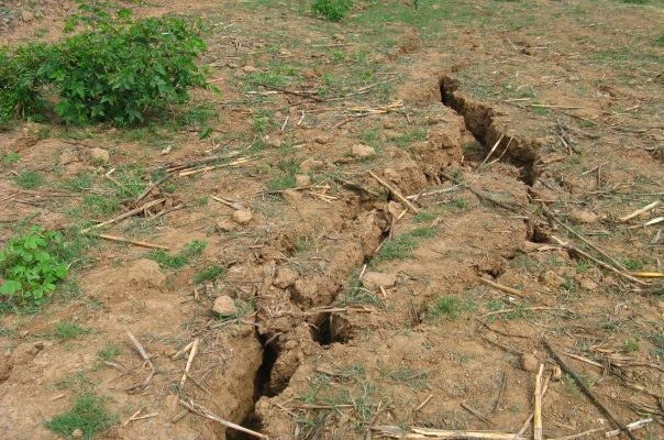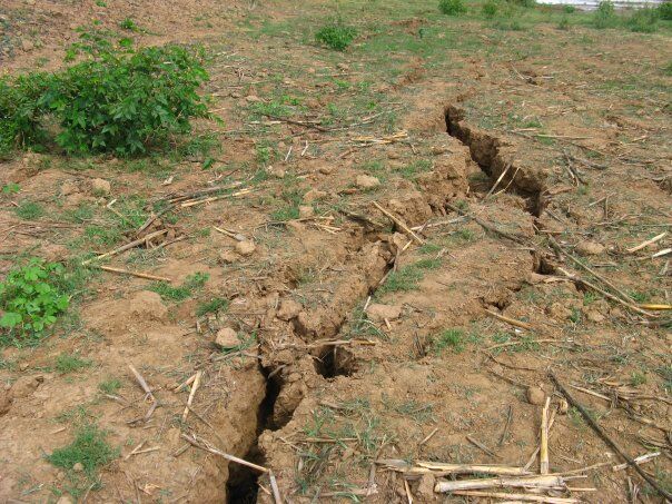
There are fears among residents of Nsanje after the district was hit by an earth tremor earlier this week.
The tremor, whose magnitude has not yet been named by authorities caused cracks on houses of people living around the area of Hapilikusala.
Reports say over twenty houses and buildings have had cracks on them as a result of the tremor.
This was days after a heavy down pour.
It is feared the tremor could signal floods in the district which is already flood prone.
Locals have since expressed their fears on the tremor. Some fear it may be the omen for more disasters to come this year, aside of floods which have already been predicted by experts.
The big question is how do floods related to earthquakes and tremors? A quick internet search indicates that the two have a linkage.
According to OpenHazards.com, flooding occurs when water arrives at a rate faster than it can drain downhill, evaporate, or absorb into the ground. Floods are commonly caused by severe storms (hurricanes, tropical storms, monsoons, thunderstorms), melting snowpack, and sudden releases of natural or man-made water barriers (dams, levees, glaciers). Deserts are prone to flash flooding because of violent heavy thundershowers and flat impermeable soils. Urban areas are also at increased risk of flooding because of the high percentage of non-absorbent surfaces (concrete, brick, etc.).

In addition to the danger of drowning, floods also create severe secondary problems. Typically, transportation to flooded areas is compromised, limiting the efforts of rescue crews. Additionally, flooding often contaminates water sources with sewage, which can create clean water shortages and outbreaks of disease for months after the waters subside. In the long run, lost crops and buildings may severely affect the local economy.
The Department of Surveys estimates that 63,531 hectares have been submerged by flood waters as of 21 January 2015 – about 245 square miles
Floods, since December 2014, affected Malawi causing rivers to overflow, floods, deaths and damage, especially in the southern districts of Nsanje, Chikwawa and Phalombe.
- A state of emergency has been declared by the President of Malawi on 13 January 2015 for 15 districts (out of 28), see affected districts on the map.
- As of 27 January (UN), the floods have affected 638 000 people (estimation) and killed at least 79 people, while 153 were still missing.
- The districts most affected are: Nsanje, Chikwawa and Phalombe, with over 170,000 displaced.
Preliminary reports show extensive damage to houses and infrastructure.


Plz government send experts there to study the place. And make a plan 4 them if necessary b4 its too late.
Where are those educated peoples to foretell this!! Before it happen? God!! Knows before or after.repent.
The end is near
Mwina Gwanda simudalemekeze maliro ake
Mother nature
Mmmmm kaya tithawira pati
M’masiku otsiriza kuzakhala zivomezi zoopsya .mat.24 mark13 luka 21
A week ago n magnitude not known yet??? Koma Malawi suzatheka.. NDE mma office mukutanimo a geological???
Oh shame
Ingosamukani Pilizi.Why? Ma Floods Ku Nsaje, Zombe Kunsanje, Tremor Kunsaje, Mphepo Ya Nkuntho Ku Nsaje,ng’amba Kunsanje, Munthu Sungakhale Ndi Mtendere.
Anthu Aku Nsanje Mudamangitsa Aniva( Nsanje Hyena) Lero Ndi Zimendzo Muwona Zoopsa Aniva Wakwiya.
Hahaha mizimu yakwiya!
NANKHA OSANGOSAMUKAKO ANTHUWO NKUKAPEZA MALO MA DERA ENA TO AVOID THOSE ISSUES
Chivomezi ichi
Yakwiya ndi mizimu
Zandiopsa!! kungosamukako asanamezedwe ndi nthaka kkkkkkkkk
Thats naturally nofng w can do rather van skng Gods hepl & w ar suposd 2 knw dat those fngs were alrdy prdcted by Holy scrptures dat it shud b hapen.
Thats last days!!no wonder
…… no need to panic, it’s just a tremor not even earth kwek……!! if it comes agains everyone must stand by nearby pillar which can’t shake @all, you’ll survive…….
Its gud that those in fear have all survived!
This thing u r showing is not a house
nice observation